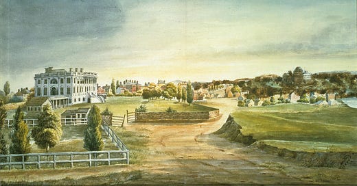
George Washington’s lifelong enthusiasm for the Potomac River and the Federal City was not shared by those who had to live in the barely-finished city after the government relocated from Philadelphia in 1800 (read Part 1 of this article here). Abigail Adams moved into the unfinished President’s House in November of that year, just four months before her husband would leave the presidency. She was perhaps the politest of those forced to endure early Washington’s inconveniences. As she wrote in her first letter to her daughter, amidst complaints about the mansion’s still-wet plaster walls and lack of servants’ bells, “The river, which runs up to Alexandria, is in full view of my window, and I see the vessels as they pass and repass” (Gutheim, The Potomac, p. 14)
(Early print of White House, with Potomac on the extreme right, from White House Historical Association)
Though the most prominent, the Potomac was just one of Washington’s many waters. The next in importance was the Eastern Branch, or Anacostia River, which joins the Potomac in the southeastern quadrant of the city, to form the Capital’s ‘Y’-shaped hydrological boundaries. On his 1608 expedition, Captain John Smith may have navigated up the Anacostia as he explored the Potomac. Over the centuries, heavy silting along the Anacostia significantly narrowed its course and mouth. As early as 1898, the U.S. Army Corps of Engineers and Congress proposed plans for dredging the Anacostia channel and reclaiming the river’s flats, in addition to reducing the litter accumulation along its banks and course. Between 1911 and 1916, Congress appropriated, and various District of Columbia boards planned, for Anacostia improvement, including landfill that further narrowed the river.
(Image from EngageDC/DC Department of Energy and Environment)
Though D.C. industrial development never approached that of a Pittsburgh or Detroit, decades of manufacturing in Southeast, driven in large part by the Navy Yard, led to the lower Anacostia becoming one of the most polluted rivers in the region. Southeast had long been perhaps the poorest area of the District, and once Whites moved out of the Anacostia neighborhood on the river’s south bank in the 1950s and 1960s due to desegregation rulings and the contemporaneous development of suburban communities in Northern Virginia and Maryland, the river and its surrounding neighborhoods became ever more neglected and polluted. The 1954 graduating class at Anacostia High School, the year Brown v. Board of Education was decided, was all-White, the last one to be so. Within a few years, Anacostia was predominantly Black, and seventy years after Brown, the neighborhoods along the south bank of the river remain roughly 90 percent Black.
Though widely recognized, the neglect of the Anacostia was often overshadowed by grander plans for revitalizing Washington, D.C. A 1972 National Capital Planning Commission plan for “the urban river,” proposed Anacostia improvements including waterfront promenades and parks, along with new residential developments, but much of the vision never came to pass.
Since the 1980s, the Anacostia has seen a slow, but extremely uneven recovery. The Anacostia Park and River Trails provides public green space, running for nine-miles, from Bladensburg, Maryland, down almost to the river’s mouth, opposite Nationals Park, and includes the Kenilworth Aquatic Gardens. On the environmental front, a Supreme Court ruling in 2006 based on the Clean Water Act reduced the amount of industrial and residential sewage poured into the river, which had lost nearly 100 percent of its wetlands. Yet the most recent report card for the river, by the Anacostia Watershed Society, gives an overall grade of “F,” with high pollution and fecal bacteria levels and a loss of aquatic plants. The Anacostia’s future remains murky, though public awareness of its problems continues to increase.
Whereas the Potomac and Anacostia, along with Rock Creek, are the most visible of Washington’s waterways, the District was once crossed by creeks and streams and dotted by springs. Cartographer and graphic designer David Ramos has put together a fascinating project on the “lost streams of D.C.,” mapping the District’s 19th century watercourses. As late as 1918, at least 150 streams were recognized in the city. Yet from Slash Run to Brown’s Spring, Ramos notes that seventy percent of Washington’s old waterways have been dammed up, dried out, turned into sewers, or otherwise covered over.
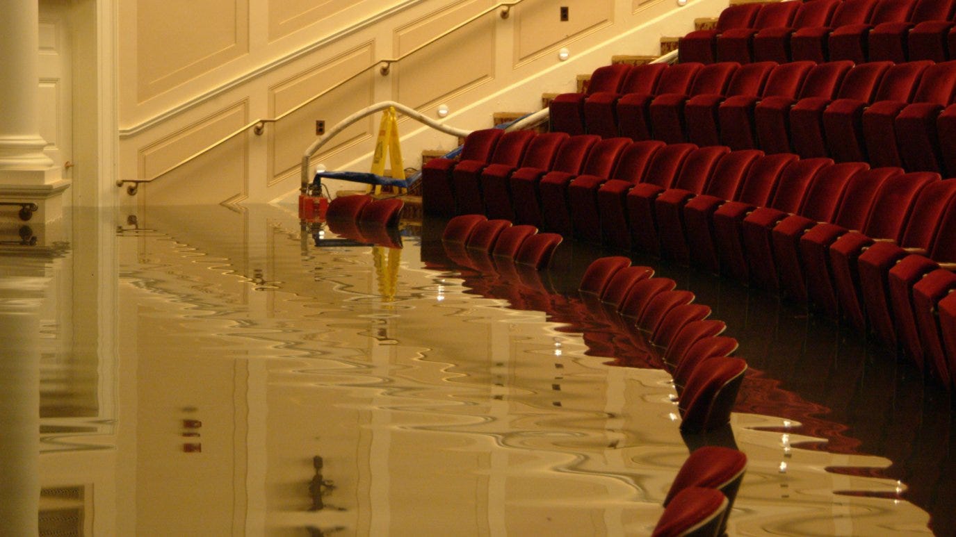
Few know that the most famous of all early Washington creeks still exists in a vestigial form. Tiber Creek, originally known as Goose Creek, once ran all the way from near the Old Soldier’s Home in Northeast, down to Capitol Hill, and past the White House, before emptying into the Potomac. By 1815 or so, it became part of the Washington City Canal, which infamously turned into a fetid, open sewer. When the Canal was finally covered over in 1870s, Tiber Creek was enclosed within a tunnel on top of which Constitution Avenue was eventually paved. Yet the underlying creek bed made sections of Constitution Avenue the lowest part of the city. During a torrential rainstorm in 2006, the National Archives underground auditorium was flooded by several feet of water, while the nearby IRS building was inundated by 24 feet of water. Since then, floodwalls, new sewers, and other measures have been adopted by government agencies to deal with the legacy of Washington’s various waterways and the topography they helped shape.
(National Archives auditorium during the 2006 flood; image from NBC4 Washington)
Despite the richness of the District’s hidden hydrology, the Potomac remains the mother of waters for the National Capital region, as foreseen by George Washington. Since the late-1800s, ensuring access to the river and taming it to serve urban purposes have vied with preserving and protecting it as a natural resource. This uneasy balance has defined the relationship between the Potomac and its surrounding environment.
Damaging floods during the 19th century led the Army Corps of Engineers to dredge the Potomac and use the artificial landfill to create East and West Potomac Parks between 1882 and 1897. Even so, the Potomac flooded the National Mall as recently as 1942. Yet unexpected benefits also emerged from the government’s battle with nature in its front yard.
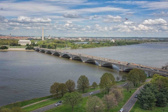
While envisioned in part as a defensive measure against the river, the reclaimed land of the Potomac Parks transformed the riverfront, creating a new Washington Channel in Southwest D.C. for the marina and a magnificent recreational waterfront for the city. The 1902 McMillan Plan further enhanced the riverfront with plans for more public access and envisioned the western extension of the Mall, where on the filled-in swampland a memorial to President Abraham Lincoln would rise in 1922. It also called for a bridge to span the river and symbolically unite North and South, from the Lincoln Memorial to the Lee Mansion; in 1932, the graceful Arlington Bridge was opened to traffic.
(Arlington Bridge; image from National Park Service)
Boating, fishing, and swimming in the Potomac were some the activities that shaped life in the National Capital for decades. President John Quincy Adams famously swam naked in the river, while on one memorable occasion, President Theodore Roosevelt also went swimming au natural with French Ambassador Jules Jusserand and other friends, after a day of scrambling among the (still) challenging river cliffs near Chain Bridge. Crew teams from Georgetown, George Washington, and regional prep schools sculled the river on early mornings, while sailboats from the marina dotted the expanse southwards towards Alexandria and fishermen filled the banks up and down river from the District.
The Potomac is far from just being a recreation spot, however. For over a century, Washington, D.C., Arlington County, Virginia, and the City of Falls Church, Virginia, have drawn their entire supply of potable water from the Potomac, while Montgomery County, Maryland, and Fairfax County, Virginia, draw part of their water from the river. I’ll have another post during the summer on the history of the Washington Aqueduct, but in short, from just above the Great Falls, water is diverted and carried to several District reservoirs and treatment plants, the main one being the Dalecarlia Plant in the Palisades. On average, 134 million gallons of water per day are brought from the Potomac to the District and Northern Virginia, while Montgomery County draws its water from farther upriver. The Potomac thus literally gives life to the National Capital Region and its six million residents.
Such growth and the demands on the rivers have not come without cost. Even before the Washington region’s massive post-World War II expansion, development along the Potomac’s lower basin led to pollution and raw sewage runoff, increased siltation, bacterial growth, and a huge increase in trash and eventually plastics along the riverbanks. In response, Congress in 1940 authorized an Interstate Commission on the Potomac River Basin (ICPRB), to include representatives from Maryland, Virginia, West Virginia, and the District of Columbia. Though only an advisory, non-regulatory commission, the ICPRB and its annual reports and strategic plans have helped coordinate multi-state initiatives on protecting the river from the region’s development.
Progress was slow, however, and in 1957, according to the ICPRB, the U.S. Public Health Service declared the Potomac unsafe for swimming, and warnings against drinking its water and eating its fish were issued. The river was almost given up for dead in the 1960s, when President Lyndon B. Johnson called the Potomac’s pollution “absolutely disgraceful” and lamented “a river of decaying sewage and rotten algae.” In 1971, the District formally banned swimming in the river, though rowing and sailing continue to be popular riparian pastimes in the Capital area. Perhaps only because Washington never developed as a major industrial area was the Potomac was spared the worst of environmental damage, but what did degrade the river was bad enough.
Since the 1970s, state and federal initiatives, including national legislation such as the Clean Water Act, have begun to restore the Potomac, even as the metropolitan region has continued to grow. In 1972, the National Capital Planning Commission released an in-depth report on The Urban River, its first set of detailed policies aiming to balance continued development with protection on the Potomac and its tributary rivers, primarily the Anacostia, within the District of Columbia.
These combined efforts have slowly led to an increase in water quality and a return of wildlife to the river. On a recent visit to the river near Little Falls, I saw bald eagles, hawks, osprey, cormorants, and turkey buzzards, which are just a few of the birds that again fill the sky over the Potomac. Even more impressive was the American Shad fairly jumping into fishermen’s buckets, along with Hickory Shad, Yellow Perch, largemouth and smallmouth bass, and river catfish. Preserving healthy fish stocks remains a government priority, given heavy fishing especially in the D.C. area, but the river steadily has returned to life in ways that might not have been expected half a century ago. Once one is away from the Washington corridor, away from the mansions looming on its cliffs and busy roadways, it is not too hard to imagine the river as Captain John Smith first saw it, in 1608, when it “exceedeth with abundance of fish.”
Myriad plans for increasing public access to the Potomac while protecting the river have been unevenly realized. Notable among recent improvements is the Georgetown Waterfront Park, which makes usable a formerly derelict part of the city’s riverfront. From weekend homes along the lower reaches of the river to the dramatic development of Southwest Washington along the Washington Channel, the Potomac’s popularity and use show no signs of waning. The metropolitan region, now numbering 6.1 million people, puts constant pressure on the river’s ecosystem, especially for treatment of sewage, riverbank erosion due to construction, and disposal of trash along the waterway. Yet progress is happening; in its most-recent report card, the Potomac Conservancy graded the river a ‘B,’ a vast improvement from the ‘D’ it rated in 2011.
Though its fish are still not considered safe to eat, and swimming remains prohibited, there are hopeful signs that the Potomac may soon be safe enough to be fully enjoyed, as it was for the century and a half when it was Washington, D.C.’s, great natural resource and playground.
Further reading: A nice piece on “Presidents and the Potomac,” is by the White House Historical Association. The ICPRB has a good timeline on efforts to restore and preserve the Potomac, as well as many other resources on the river. The Potomac Conservancy advocacy group also has a site with various resources.
And if you missed earlier recommendations: Frederick Gutheim’s now out-of-print The Potomac (1949; 1968) remains the most comprehensive overview of the river, at least up until its revised publication. Two books on George Washington and the Potomac are Joel Achenbach, The Grand Idea: George Washington's Potomac and the Race to the West (Simon and Schuster, 2004) and Robert J. Kapsch, Potomac Canal: George Washington and the Waterway West (West Virginia University Press, 2007). Among many on George Washington and the creation of the Federal City, see Robert P. Watson, George Washington's Final Battle: The Epic Struggle to Build a Capital City and a Nation (Georgetown University Press, 2021) and Adam Costanzo, George Washington’s Washington: Visions for the National Capital in the Early American Republic (University of Georgia Press, 2018); an older treatment is Kenneth R. Bowling, The Creation of Washington D.C.: The Idea and Location of the American Capital (George Mason University Press, 1991).
And remember, all the posts from The Patowmack Packet are available on the Packet’s website.


It would be of interest to learn where/how the Tidal Basin fits into this plan. On fish, the spring shad run remains an area annual high point. One can find dozens of fishermen snagging shad for their roe.